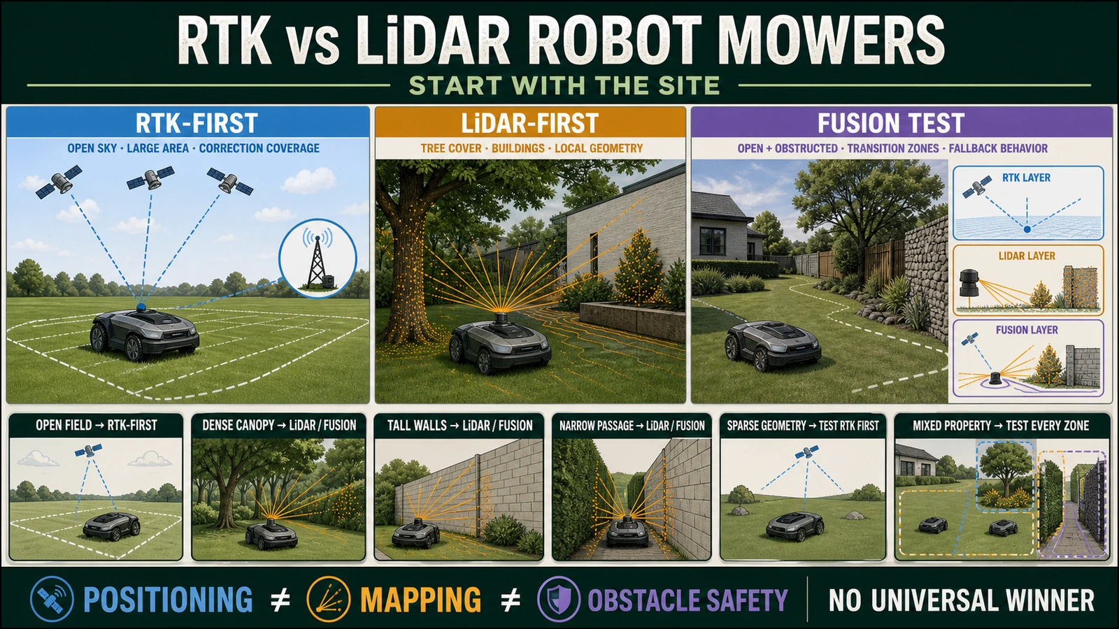
- RTK is usually the first route to assess on large open lawns with reliable satellite and correction coverage; LiDAR is usually the first route to assess where canopy, buildings and narrow passages obstruct the sky.
- Local RTK, Network RTK and LiDAR-first systems carry different infrastructure, account, mapping and service dependencies, so the complete SKU and market version matter more than the headline sensor.
- Mixed sites should be commissioned as multi-zone systems: test sensor transitions, degraded operation, boundary repeatability, docking and map recovery before acceptance.
In this article 9 sections
Start with an RTK robot mower for a large, open lawn with reliable satellite reception and correction coverage. Start with LiDAR where trees and buildings obstruct the sky but provide usable local features for mapping. For a property that combines both conditions, test a mower that combines navigation methods across the whole route.
Imagine an open front lawn connected to a shaded rear garden by a narrow passage beside the house. A mower could have a clear satellite view at the front, lose that view beside the building and need a different positioning reference under the trees.
That is why the same machine can be a good fit for one garden and a difficult installation in another. Before choosing RTK or LiDAR, follow the route the mower will actually travel: out of the dock, through each work zone and home again.
RTK vs LiDAR Robot Lawn Mowers at a Glance
| Your property or priority | First system to assess | What to check before buying |
|---|---|---|
| Large, open lawn | RTK | Satellite reception and correction coverage at the far edges as well as near the dock |
| Tree-covered garden or enclosed courtyard | LiDAR or a suitable combined system | Reliable mapping and repeated operation under the actual canopy and beside buildings |
| Open lawn joined to shaded areas | Combined navigation | Behavior when moving between open and obstructed zones |
| Avoid installing a local RTK antenna | Network RTK or LiDAR | Network RTK coverage and connectivity, or LiDAR mapping requirements |
| Weak mobile or Wi-Fi coverage | A model with a documented local navigation route | Which functions work offline; a local RTK station still needs suitable satellite reception |
| Lowest installation effort | Compare complete installations | Mapping, station placement, site changes and support matter alongside the sensor |
These are starting points for a site trial. The exact model, software and regional services determine whether a candidate can reliably maintain the property.
Why Do RTK and LiDAR Suit Different Gardens?
RTK uses satellite signals together with correction data to estimate a precise position. The corrections can come from a local reference station or a network service. With reliable reception, that position helps the mower follow virtual boundaries and planned routes.
LiDAR measures distances to surrounding surfaces using laser pulses. Together with mapping software and other onboard sensors, it can help the mower recognize where it is within a local map.
The difference explains the garden problem. An open lawn can offer good satellite visibility while providing relatively few nearby features. A garden enclosed by walls and trees may offer plenty of local structure while obstructing the sky.
Husqvarna's EPOS installation guidance identifies trees and buildings as potential satellite obstructions and describes different ways its models handle weak reception. It is a useful example of why the installation site belongs in the buying decision.
For other approaches, including vision and boundary-wire systems, see our wire-free robot lawn mower guide.
When Is RTK the Better Starting Point?
A broad lawn with a clear sky view is a strong candidate. Satellite-based positioning gives the mower a reference across the property without requiring nearby walls or trees throughout the route.
The important qualification is “throughout the route.” A good signal beside the charging station does not establish that the machine can work along the house, behind a garage or under a large tree. Walk those edges before ordering.
The source of correction data also changes what you are buying.
Local RTK: a station becomes part of the garden
A local reference station needs a suitable position, power and communication with the mower. It also needs the sky view specified by the manufacturer.
Once installed, treat it as part of the positioning setup. Check the model's procedure before moving it or changing the dock and boundaries. A later garden rearrangement may require a new setup or map.
Network RTK: check coverage before removing the antenna
Network RTK can avoid a customer-installed reference station by receiving corrections from a service network. The mower still needs usable satellite reception, and the relevant connectivity and service coverage must reach the property.
Husqvarna's cloud installation option, for example, requires stable internet across the work area and is available only in supported markets. Its local-station option provides a different route for navigation. Those are model-specific arrangements, so a buyer should confirm the terms for the exact machine.
Ask the seller to separate correction access, mobile data and remote app functions. Record what is included, for how long and what happens during an interruption. “No antenna” answers an installation question; service details determine how that installation keeps working.
Navimow's European i2 LiDAR Pro product page, checked on September 6, 2026, shows why this distinction matters. It lists Network RTK access and the cellular data required for it at no extra cost. Separately, it lists one year of data for remote app control, alerts and tracking, followed by a paid renewal. Buyers should verify the regional terms, but they should not interpret the end of a remote-control data offer as automatically ending the positioning service.
Does LiDAR Solve the Problem Under Trees?
LiDAR can use nearby surfaces when satellite reception is weak, making it a useful candidate for shaded gardens and enclosed spaces. It still needs a usable map and reliable readings from the environment.
Think about a route beside hedges, through a narrow passage and into a courtyard. The mower must recognize its surroundings, stay within the accepted boundary and return through the same passage. Those steps deserve a demonstration on the actual property.
Changing vegetation, sensor contamination and features such as glass or repetitive corridors are reasons to test carefully. They do not establish that every LiDAR mower will fail there. What matters is how the selected machine handles that particular route.
Installation also varies. Dreame's A1 mapping instructions require the operator to drive the boundary using the app after preparing the docked mower. Navimow describes automatic mapping for its i2 LiDAR, which combines LiDAR and vision. Both carry a LiDAR label, but the owner's setup tasks differ.
LiDAR ranging can operate without visible daylight. If the mower also relies on cameras for other functions, check those functions separately before assuming that all behavior is unchanged at night.
What If the Lawn Has Both Open and Shaded Areas?
Return to the front-lawn-and-rear-garden example. A combined navigation system can draw on different references as the surroundings change. This is the practical reason to consider sensor fusion.
The benefit depends on the software. The machine needs to continue with a reliable position or stop appropriately when that position becomes uncertain. Simply listing RTK, LiDAR and cameras does not demonstrate successful recovery.
A product example: Navimow i2 LiDAR versus i2 LiDAR Pro
The official European pages describe i2 LiDAR as using LiDAR and vision, with positioning that does not depend on satellites. The i2 LiDAR Pro adds Network RTK to the LiDAR-and-vision combination. These configurations were checked on September 6, 2026.
That changes the installation questions. For the LiDAR model, assess local mapping and the actual route. For the Pro, also verify Network RTK coverage and what the mower does when one positioning source weakens. The additional sensor layer provides another reference; the product page alone does not prove that the Pro performs better on every lawn.
Ask the dealer to run the difficult connection between zones. Watch whether the mower passes through, completes the rear lawn and finds its dock again. Repeat the route rather than accepting one successful run. If the manufacturer permits a controlled interruption test, check the documented stop or recovery behavior with the installer.
Model suffixes and regional versions matter here. Confirm the actual navigation equipment and included services for the unit on the quotation. Our LUBA versus Navimow comparison provides a separate brand and product context; site suitability still needs its own check.
Will Better Positioning Also Improve Obstacle Avoidance?
Positioning tells a mower where it is. Obstacle detection helps it respond to something in its path. A product may use overlapping sensors for these tasks, but the capabilities need separate evidence.
A mower can follow a planned line precisely while still needing another sensing system to recognize a temporary object. LiDAR can measure a shape without proving that the software identifies what it is. Camera-based recognition has its own limits.
Keep three questions separate during the demonstration:
- Navigation: Does it complete the route and return to charge?
- Boundary control: Does it repeatedly stay within the accepted work area?
- Obstacle response: Which objects and conditions does the manufacturer claim to detect, and what happens when detection is uncertain?
Near roads, water and drop-offs, follow the exact manual's separation and physical-protection requirements. Never use people or animals as test obstacles. Precise positioning alone does not establish safe behavior at every edge.
What Should a Dealer Prove Before Delivery?
The useful demonstration starts with the hardest part of the garden. A tidy pass across the open center leaves too many important questions unanswered.
Ask for a site plan showing the open areas, canopy, narrow connections, slopes, high-risk edges and dock. For RTK, add the proposed station or correction service and relevant coverage. For LiDAR, identify the route and surroundings the system must map. This makes the recommendation explainable before money changes hands.
Then agree on a short acceptance record that the owner and dealer can both use:
| Installation check | Evidence to keep |
|---|---|
| Complete product and services | Model, market version, firmware, accessories and separate correction, cellular and cloud terms |
| Every distinct work zone | Site plan and trial results for open lawn, canopy, narrow passages, slopes and the return route |
| Repeatable operation | Boundary and docking results, plus documented stop or recovery behavior during any manufacturer-approved interruption test |
| Recoverable setup | Accepted map version, station positions, account owner and map backup or replacement procedure |
| Changes after installation | Which station moves, landscaping changes or boundary edits require the dealer to check the setup again |
| A clear service owner | Installer, warranty intake and repair contacts; responsibility for travel, labor, hardware replacement and restoring the map |
Do not record a manually traced map as proof of autonomous operation. The mower should repeat the route under its own control. Likewise, a successful pass across the open lawn does not establish that it can return through the shaded passage.
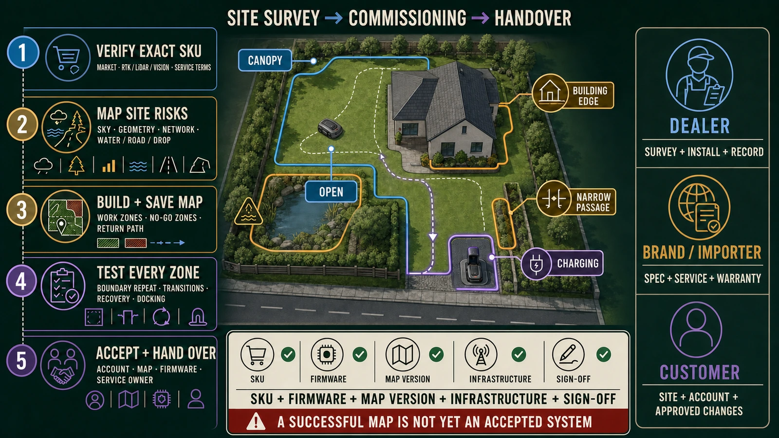
Our robot lawn mower installation guide covers the fuller setup process. For this comparison, the outcome is straightforward: the mower should demonstrate that it can complete the agreed route under the site's expected conditions.
Which System Is Likely to Cost Less to Live With?
Include installation and support in the comparison. A local RTK station can add hardware and mounting work. Network RTK can add service dependencies whose terms need checking. A LiDAR system still needs mapping, sensor care and a procedure for recovering or rebuilding a map.
Consider who returns if the mower repeatedly stops behind the house. Is that visit covered as installation support? Does the seller check connectivity before requesting a repair? Who restores the map if the machine is replaced?
For a dealer, those questions affect service workload and margin. For an owner, they determine whether a problem becomes one support call or repeated attempts to explain the garden to different companies.
Choose the system that has a convincing answer for the property and a clear person responsible for making it work. RTK is a strong starting point for open conditions, LiDAR for suitable structured and obstructed spaces, and combined navigation for mixed routes. The final choice should follow what the machine demonstrates across your lawn.
FAQ
Is RTK better than LiDAR for a robot lawn mower?
RTK is often the better first option for a large open lawn with reliable satellite and correction coverage. LiDAR is often the better first option where tree cover, buildings and narrow passages obstruct the sky. Mixed properties should test a fusion system.
Does an RTK robot mower need an antenna?
Local RTK normally uses a reference station. Network RTK can remove the customer-installed antenna, but it may add correction coverage, internet, account and service dependencies. Check the exact model and market.
Does LiDAR work under trees?
LiDAR can localize from local geometry without depending on satellite visibility, so it is a strong candidate under canopy. Performance still depends on the exact sensor, map, software, environmental change and other onboard sensors. Test the actual property.
Does LiDAR work at night?
LiDAR ranging does not require visible daylight. The mower may still use cameras or other systems whose night behavior differs. Verify the complete product, not the LiDAR alone.
Is LiDAR used for navigation or obstacle avoidance?
It can support either or both. Some products use LiDAR mainly for positioning and mapping; others also use it for perception. Object classification and safety may depend on vision and additional sensors.
Is Network RTK the same as GPS?
Network RTK uses GNSS satellite signals plus correction data from a service network to improve positioning. It is not ordinary standalone GPS, and it still needs suitable satellite reception.
Which system is better near tall buildings?
Tall buildings can block and reflect satellite signals, so LiDAR or fusion deserves the first site trial. Test glass, repeated corridors, transitions into open space and every high-risk boundary.
Why do some new robot mowers use RTK, LiDAR and vision together?
The sensors provide different references. RTK supplies global positioning, LiDAR supplies local geometry and vision can add scene understanding. The benefit depends on how the software combines them and recovers when one layer weakens.
What should a dealer test before delivery?
Test every distinct zone, boundary repeatability, transition areas, docking, recovery after an approved interruption, map continuity, account transfer and the documented fallback behavior. Record the accepted firmware, map and infrastructure.
Explore 2026 new models